
In his latest book, editor Brent McKean explores 40 of Australia’s most spectacular coastal walking tracks. In this edited extract he takes us on a journey along Victoria’s oldest national park and into the labyrinth that is Wilsons Promontory…
The Lightstation Walk
By ANDREA PURNOMO

TRACK FACTS
Where: Wilsons Promontory, 222km south-east of Melbourne.
Start and finish: Tidal River car park.
How long: 46km circuit, three to four days.
Degree of difficulty: medium-challenging, with sand walking and steep cliffs.
More info: parks.vic.gov.au.
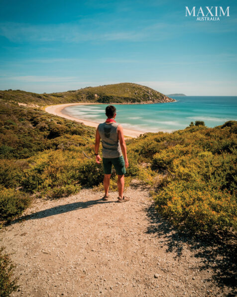
Wilsons Promontory is known for its rich landscapes and labyrinth of walking tracks. One of its longest walks, the 46km Wilsons Promontory Lightstation Walk, leads hikers to the most southern tip of mainland Australia. Located in Victoria’s oldest national park, Wilsons Promontory was discovered by sea in 1798 on an expedition led by George Bass.
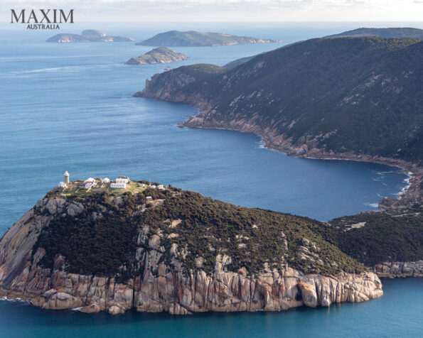
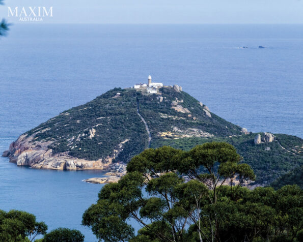
Geographically, the most southern tip of mainland Australia is called South Point; however, due to the spectacular view and heritage of the Wilsons Promontory Lightstation another 4km to the southeast, the lighthouse became a popular and favourable destination visited by many. South Point is not the easiest point to reach, involving a two-day hike and an overnight camp with Sealers Cove Refuge Cove Kersops Peak South East Point no vehicle access. Both South Point and the lighthouse overlook Bass Strait and showcase a spectacular view of infinite ocean.
Wilsons Promontory’s Tidal River car park is 222km south of Melbourne. You’ll need to collect a permit at the Tidal River Visitor Centre before heading off. To begin the walk, set off towards Oberon Bay via the coastal trek. This moderate walk is a perfect start to the hike and has magnificent views of Victoria’s coast. You’ll pass varying terrain, and there are tracks that lead across three different beach shores at Norman Bay and Little Oberon Bay Beach.
Each sandy terrain will beckon you to shimmering grains of beige. Among the conversations and Kodak moments of the majestic scenery you’ll come across a shaded path that could be a resting place for brown tiger snakes. Wilsons Prom is home to three species of snakes that can be found hiding in shaded areas of the park. Even with the abundance of snakes, not every hiker is fortunate – or unfortunate – enough to spot one. Located within Little Oberon Bay Beach, Oberon Bay Campsite has beachside accommodation, with camping grounds in close proximity to the beach.
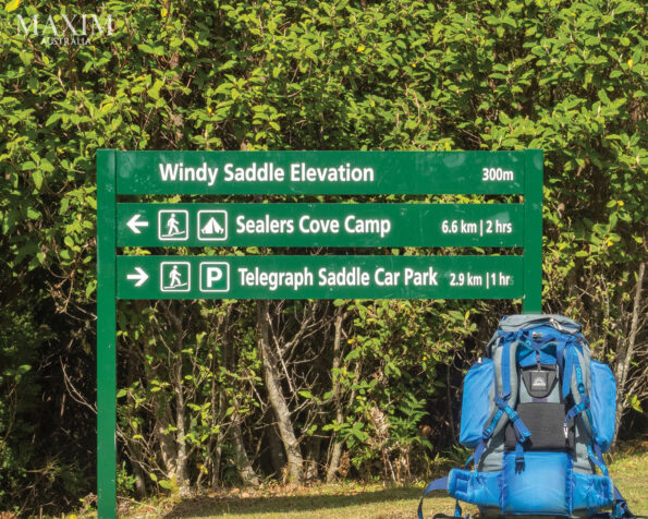
You’ll trek a moderate 5.6km and pass Halfway Hut Camping Area, then further on you’ll reach Roaring Meg Camping Area via the Telegraph Track. The terrain changes to a dark rockbound road that winds through an endless burned-looking valley that is significantly distinctive from the previous colourful landscapes. The track leads to a mountain, trails up and then ultimately takes you down into bushscape.
The surroundings are spectacular, and you may be lucky enough to witness wallabies hopping alongside you. Be entertained by the social Victorian wildlife as you make your way to the Roaring Meg campsite, the most southern unpowered site. It is a large yet cozy, lush site with its own creek and bridge. On the next day you can leave your gear at the campsite, hike to the lighthouse and back and then trek back. You’ll walk over fog-covered tracks, flower-filled footpaths and branch evading byways. The track paves its way up the mountain and has lookout clearings that face an endless ocean. Enjoy the landscape until you finally reach the lighthouse after conquering the long and steeply paved road baptised ‘heartbreak hill’.
The lighthouse keeper is usually amenable to taking you around and explaining the history of the lighthouse and his job of maintaining it. Built with local granite by stonemasons in 1859, the 19-metre-tall, seaman-saving beacon towers over the wild waters of Bass Strait. If you book ahead you can stay at one of the three refurbished lighthouse keeper-style cottages and wake up to incredible views of the ocean. It’s truly amazing witnessing the sunset over Bass Strait, and especially in the colder months by the fireplace of your cabin. As you sit on the very edge of Australia’s south you won’t be able to help but reflect on life while overlooking the view of a limitless ocean. It is breathtakingly serene sitting there.
By the way, the lighthouse keeper drives one of the most expensive utes in Australia because to get it to the lighthouse it had to dismantled, flown by helicopter and then reassembled onsite! As the only location with water facilities available it is recommended you refill your water bottle before commencing the hike back to Roaring Meg.
Retrace the walking track back towards the Halfway Hut Camping Area. If you like you can take the 12km Telegraph Track towards Telegraph Saddle car park, which will halve your hiking time. This track cuts straight through the centre of the national park, and on weekends the park provides a free shuttle service from Telegraph Saddle car park to Tidal River.
The elongated track winds through a mountain. The terrain changes to a paved road shaded by overgrown trees as you come across a water oasis that is perfect for a pit stop. Take in as much of the surroundings as you can as your uphill ascent continues for another 15 minutes, until you encounter the clearing of the Telegraph Saddle car park.
The National Park
Words and photography by BRENT McKEAN
TRACK FACTS
Where: Wilsons Promontory, 222km south-east of Melbourne.
Start and finish: Tidal River Campground.
How long: various.
Degree of difficulty: easy-challenging.
More info: parkweb.vic.gov.au; visitvictoria.com/Regions/Gippsland.
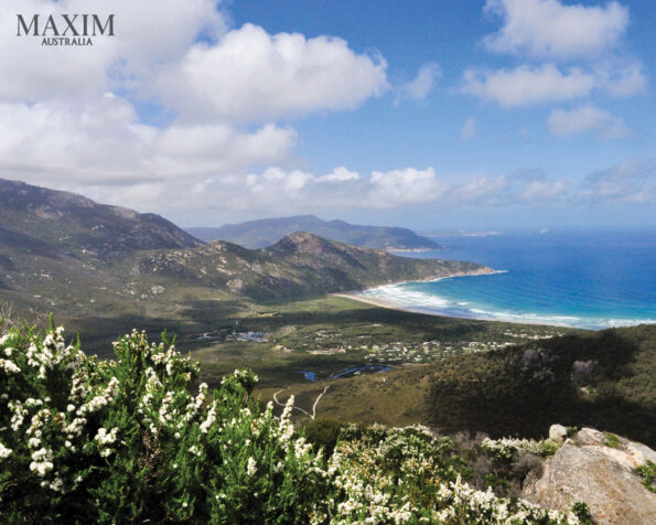
Wilsons Promontory National Park, the southernmost tip of mainland Australia, offers exceptional coastal and wilderness walking, pristine beaches dominated by granite tors, wildlife aplenty and comfortable, family-friendly campgrounds. After crunching your way up the stringybark forest and sliding between large granite boulders you’ll finally reach the top of Vereker Lookout in the northern part of Wilsons Promontory.
Carefully climb on top of the highest rock you can find, take a deep breath and slowly exhale: there aren’t many moments in your life when you’re completely alone in the wilderness, where all you can hear is the breeze and all you can see for miles and miles is beach, bush and bluffs.
Wilsons Promontory is Victoria’s most-beloved national park, and when you stand on that summit you will see why. It’s home to a wide range of wildlife such as kangaroos, wombats, echidnas and emus, and there are plenty of species of birds to spot including colourful and curious rosellas. As for bushwalking, the news just gets better: there are dozens of short, half-day and multi-day trails that allow you to explore the variety of terrain the prom has to offer, from long pristine coastline and exposed headlands to steep granite outlooks and secluded rainforest.
The main visitor hub, the Tidal River Campground, is a 30-minute drive from the park’s entrance and features more than 480 camping and caravan sites. The nearest walk to do is out to Squeaky Beach via Tidal Overlook. This easy 90-minute trail offers the best views of the prom’s west coast as it climbs the headland between Norman and Leonard bays before descending to Squeaky Beach. The walk can be started from the Tidal River footbridge or the Lilly Pilly Gully car park – and, yes, Squeaky Beach was named after the sound of your feet on the sand!
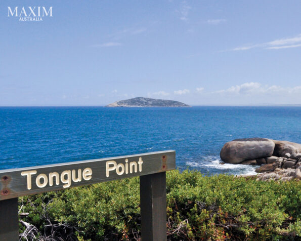
If you’re looking for another walk out to a headland with great coastal views, try the moderate-grade Darby Saddle/Tongue Point/Darby River walk of 9.4km. To do this you’ll need two cars: one at the start at Darby Saddle and one at Darby River. If you have one car then simply walk from Darby Saddle to Tongue Point, which is 5.6km. Tongue Point is a coastal headland littered with tumbled stacks and boulders of weathered granite. The track from Darby Saddle provides wonderful coastal and forest scenery as it climbs uphill through stringybark and casuarina forest. At 2.1km, a 300-metre sidetrack leads up to Sparkes Lookout and offers commanding views of the pyramid-shaped Rodondo Island to the south and Shallow Inlet to the north.
After the turn-off the main track climbs steeply to Lookout Rocks, a vantage point with wonderful views of Norman Island. From there the track descends steeply through low heathland, then joins the track from Darby River and continues to Tongue Point. Part of the trail is on raised plastic duckboards that offer a reassuring grip and look as though they have more longevity than wooden ones, which need constant maintenance on walks such as Tassie’s Overland Track. From Tongue Point the trail heads north to Darby River and offers lush views up Darby and Cotters beaches.
If you fancy getting your heart rate up at the end of the walk, take the 1km sandy track from the car park to Darby Beach. Looking north you’ll see a very steep, very high sand dune. To reach the base of the dune you’ll have to cross the shallow inlet, and then the only way is up. It takes some effort to push through the soft sand, but once you’re at the top it will be worth it.
Looking east you can see the next destination of the Vereker Range snaking its way along the north of the park. After all the effort of reaching the top of the sand dune the only thing left to do is to slide barefoot down it laughing uncontrollably like a silly schoolboy. If you spot any snakes along the way don’t be alarmed: if you don’t hassle them, they won’t hassle you. You’re less likely to see them if you’re walking in a group as they’ll feel the vibrations of all of your feet on the track and make themselves scarce. Either way it’s not something to be too concerned about.
Wilsons Promontory’s lesser-visited northern section offers a fine selection of walks, including the walk to Vereker Lookout. The view looks west to Darby Saddle, where you’ve just come from, Corner Inlet, Shellback Island and Cotters Beach. Starting at Five Mile car park, the 6km easy to moderate track to Vereker Lookout winds through open banksia woodland with a heathland understorey. For the first 45 minutes the track follows this quiet area before heading up into stringybark forest and the mass of granite boulders that defines this part of the prom. Don’t be surprised if you see emus and wallabies curiously staring at you; they’re all part of the show.
Many of the prehistoric granite boulders that loom over you wouldn’t look out of place at Stonehenge. No doubt the original inhabitants of the Prom, the Brataualung, would have found this place just as blissful. For traditional owner groups Wilsons Promontory is part of a spiritually significant land called Yiruk or Wamoom. Shell middens behind many beaches date back thousands of years and demonstrate a deep connection between Indigenous people and the prom’s land and sea. Before the last ice age 65,000 years ago this part of Victoria was connected with Tasmania by way of a land bridge, which is how the original inhabitants of the Apple Isle got there. What’s left of the land bridge is now the 52 islands that make up the Furneaux Group.
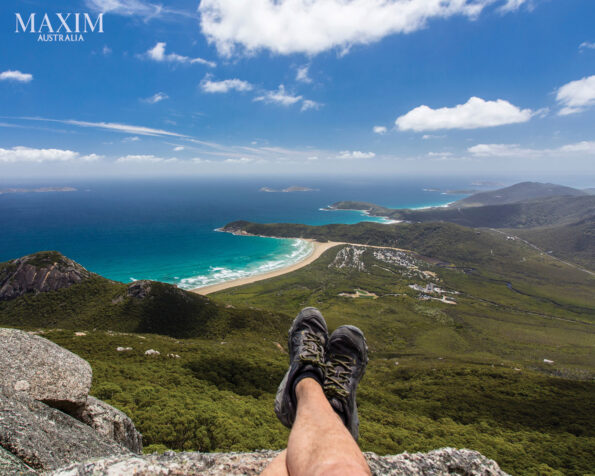
One of the most popular walks at the prom is the Lilly Pilly Gully Circuit Walk and the side trip up to the exposed granite mass of Mount Bishop. This 7.5km easy walk provides a good example of the prom’s interior as the track travels into one of the southernmost locations of warm temperate rainforest. Gnarled coast banksia, wattle trees, hakea and heathland plants all vie for space on this special walk. Give yourself plenty of time to check out your surrounds, and if you’re lucky you’ll spot a koala hanging in one of the gum trees that offer shade.
The 360-degree view from the top of Mount Bishop is commanding: you really get a feel for the variety of geography that makes up the prom and you’ll regret it if you haven’t brought along a camera. This is picture postcard stuff. Three days exploring Wilsons Prom will allow you to get a good taste of what it has to offer bushwalkers, but it wouldn’t hurt to stay another three days more.

GREAT COASTAL WALKS AUSTRALIA by Brent McKean (Gelding Street Press $39.99rrp) is available at BIG W and all good bookstorES
For the full article grab the April 2025 issue of MAXIM Australia from newsagents and convenience locations. Subscribe here.

