
In his latest book, editor Brent McKean explores 40 of Australia’s most spectacular coastal walking tracks. In this edited extract we take a journey to Byron Bay’s humpback highway and Tasmania’s perfect peninsulas…
The Whale Trail
By PETA MURRAY

TRACK FACTS
Where: Whale Trail, Byron Bay, 65km south of Tweed Heads.
Start and finish: Byron Bay to Ballina.
How long: 36km one way, two to three days.
Degree of difficulty: easy to moderate, with some sand walking and steps. Tallow and Seven Mile beaches are best walked at low tide.
Further information: coffstrails.com
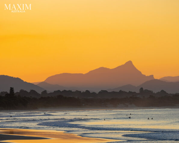
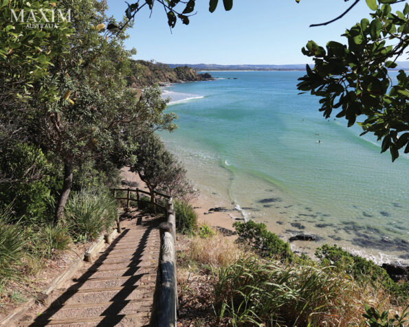
Byron Bay may be better known for its hipsters than its hiking trails, but this surf destination is the gateway to a humpback highway, and you can experience it all on the 36-km Whale Trail. The coastal walk between the northern New South Wales towns of Byron Bay and Ballina, with its lure of whales, begins from Byron Surf Club, a stone’s throw from the town centre. The path hugs the dunes behind Main Beach and the sparse tree line shows glimpses of glittering ocean beyond. From Clarkes Beach the track begins a gentle ascent up Lighthouse Road. A timber boardwalk unveils the rolling sets of world-famous surf break The Pass, the panorama taking in the length of Byron’s beaches and the twin domes of Julian Rocks backdropped by the distant ranges and Wollumbin’s distinctive peak.
The trail leaves the road and dips down to the Cape Byron State Conservation Area, where brush turkeys scratch surreptitiously in the scrub and koalas are sometimes spotted high in the rangy eucalypts. You’ll wend over to Wategos Beach, another hotly contested wave fringed by a sandy cove and some of the nation’s most expensive real estate, then have a steep but short upward clamber to Australia’s most easterly point: crowned by Byron’s 120-year-old white-washed lighthouse, the country’s most powerful light station. It sends a signal 50km out to sea.
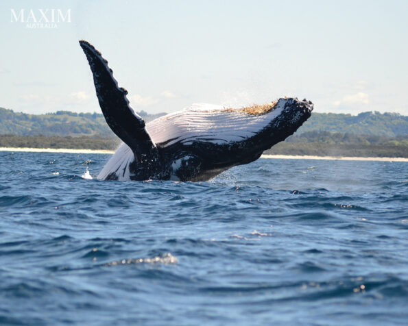
Don’t forget to scan the vast expanse of ocean for a misty spume or distant displacement of white water, telltale signs of humpback whales on their annual east coast migration. From the lighthouse you’ll track across fenced clifftops falling sheer to the sea before shaded woodlands loop you 1km back down the western side of the hill and along the road to Cosy Corner, tucked beneath the beam of Byron’s historic light. Here at the northern end of Tallow Beach, named for the candle-bound cargo of a ship wrecked off the cape in 1864, the ocean is a roiling tumble of green waves and spray sprinkled with seasoned surfers.
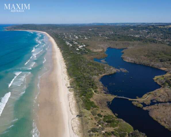
Half an hour’s hiking along the packed sand of low tide will take you past one of New South Wales’ smallest reserves, the tiny Arakwal National Park, to its southern boundary Tallow Creek, a waterway snaking behind the dunes that opens sporadically to the sea. With the national park home to more than 120 species of bird, the creek is an important feeding ground for pelicans, egrets, little terns and beach stone curlews.
The weather is changeable around the cape and sudden squalls may scud in from the east, dusting you in a light shower of rain and throwing up a cluster of the rainbows for which this region is known. The remaining 4km are walked between untamed ocean currents and stands of dense coastal heath featuring pandanus and banksia, the dunes gradually giving way to the village of Suffolk Park and its neighbouring Ti-Tree Lakes. Coloured by the coppery tannins leached from the surrounding trees, the lakes are said to have medicinal qualities and are regarded by the local Bundjalung people as a sacred women’s site.
Broken Head Holiday Park makes a good overnight choice: here you’ll be serenaded to sleep by the soothing sound of the waves and then be ready the next morning to tackle Broken Head Nature Reserve, a wind-whipped stand of forest scoring the headland across to Seven Mile Beach. Hiking through the reserve means taking the dirt road along the escarpment, although there’ll be plenty of opportunities along the way for snapshots of ocean gleaned through littoral rainforest peppered with palms and pines, catbirds, wompoo fruit doves and the occasional shy pademelon hiding in the undergrowth.
Host to a bevy of Byron Shire’s prettiest beaches, the headland will string you high above the secluded sands of Kings, Brays and Whites beaches. A visit to each of these coves down narrow tracks can easily add a couple of hours to your hike but makes for a worthy detour. You’ll wind down from Jews Point to arrive on the sands of Seven Mile Beach, which despite its boast is only 5.3 miles (8.5km) long, and will likely see pied oystercatchers with their distinctive red beaks scurry away at our approach.
Beyond the dunes lie the brackish waters of Lake Ainsworth, another tea tree-infused freshwater lagoon that gains its name from farmer and early European settler to the area James Ainsworth. The seaside village of Lennox Head will eventually appear, overshadowed by its eponymous hulking headland and Pat Morton Lookout, the launching ground for hang gliders on a breezy day. A shallow reef sits off the southern end of the beach, ideal for snorkelling at low tide, while further out the point’s renowned right-hand wave washes in over basalt rocks.

On the third day you’ll embark on the most scenic section of the coastal track. Tracing the headland up a set of wooden stairs, you’ll walk through scrubby heath before the panorama opens onto a posse of padlocks, odes to love adorning the clifftop’s wire fence. Cradling the coastline, the trail sweeps across a grassy bluff where unbroken ocean views provide the perfect vantage point to spy whales. Spears of spume will alert you to the passing parade of migrating humpbacks, an occasional tail flick or fin splash churning up the sea while brahminy kites sail effortlessly on the zephyrs above.
The track brings you to the aptly named Boulder Beach, where the stones rattle on a rising tide. You’ll skirt a low-lying lagoon alive with the throaty chorus of frogs to reach the jutting chin of Iron Peg, another green eyrie overlooking a rock-laced surf break where dolphins and board riders skim the swell. There is a scramble up Skennars Head, the second steep ascent of the trail. The third of the grassy knolls, Skennars Head is also gateway to the coast recreational path, a paved track that threads the woodland behind the dunes and the pearly necklace of beaches studded south along the eastern shore.
Sharpes Beach, accessible by both sand or pathway, gives way to Flat Rock, a stony platform that drips into the sea and lays technical claim at low tide to being the easternmost point of Australia. You will pass through groves of paperbark, coastal cypress pines and a thick green carpet of pink-eared pigface as tiny blue-headed fairy wrens flit silently through the branches, eastern whipbirds slice the air with their signature call and shiny-skinned land mullets scrabble for the safety of denser scrub.
The paved path eventually veers up to the road, leaving a sandy bush trail that will deposit you at the southern end of Angels Beach. The stark silhouette of Black Head looms, a site tarnished by the tragic massacre of Aboriginal tribes in the 1850s. Home to Indigenous clans for more than 12,000 years, this country around East Ballina remains a significant place for First Nations people.
Once you gain the southern reaches of Shelly Beach’s pebbled shore you’ll head over the rise to Lighthouse Beach and its nineteenth-century namesake, one of the oldest light stations in New South Wales, and finally arrive at Ballina’s northern break wall, a jumble of rocks and concrete blocks shepherding the Richmond River out to sea. You may see a pod of dolphins playing on the outgoing tide and whales casually breaching a few hundred metres off the break wall, a cetacean salute to the setting sun.
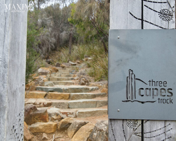
Three Capes Track
By BRENT McKEAN
TRACK FACTS
Where: Tasman National Park, 56km south of Hobart.
Start and finish: Port Arthur to Fortescue Bay.
How long: 48km one way, four days.
Degree of difficult: moderate.
Further information: threecapestrack.com.au; parks.tas.gov.au; lifesanadventure.com.au.
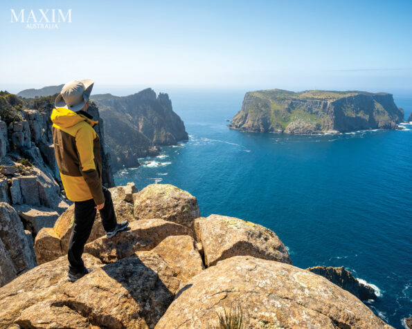
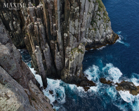
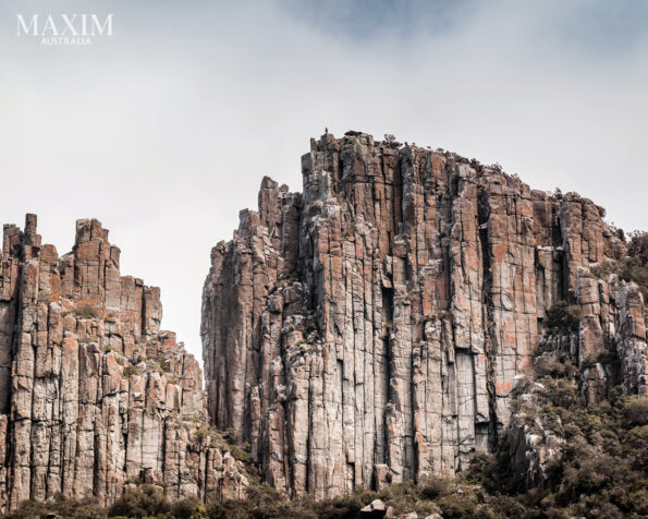
This 84km walk showcases the natural beauty of the Tasman Peninsula, a region famous for its three spectacular capes featuring the highest vertical seas cliffs in Australia and a dramatic coastline of caves and towering sea stacks. The first person to successfully swim the shark infested waters off the Tasman Peninsula was a bushranger name Martin Cash, in 1840 to escape the terrors of Port Arthur. Back then the penal colony was surrounded by high walls, armed guards, impenetrable bush, impossibly high sea cliffs and those uninviting waters, all making it escape proof. Well, almost.
I was introduced to Martin Cash by my Life’s An Adventure guide Danny as we began our Three Capes Track walk. Danny is a local, and as he knows a whole lot about the state he loves telling stories about the characters who add so much colour to Tassie’s history. There are several ways you can walk the Three Capes. The official Three Capes Track takes four days and you stay at modern public huts or Tasmanian Walking Company’s private lodges. You can do day walks out to some of the capes or have a guided tour with an operator such as Life’s An Adventure, who will show you the best bits of the area.
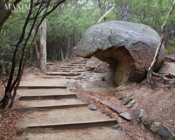
This Three Capes walk started off with a lovely bus ride from Hobart to the start of the walk in Tasman National Park on the peninsula. This place is pretty special as it’s home to more than one-third of Tasmania’s recorded plant species, including more than 60 that are threatened. The destination for the day was Cape Raoul. From the car park the 14-km return trail starts along a quiet eucalypt forest and continues past flowing streams and over a couple of log bridges. You’ll see some interesting art installations along the way that are part of the official Three Capes Track experience, including a wooden bench that wouldn’t look out of place in Game of Thrones. After an hour the trail begins to run along the edge of the rising peninsula and offers stunning views of the mighty Tasman Sea, a taste of vistas to come.
After another good hour of moderate-level walking the trail plateaus out onto an open track through banksia scrub. Two well-built platforms offered excellent views of Tasman and Bruny islands, the southern capes and Shipstern Bluff. The exposed top is famous for its mighty gusts, some of the strongest recorded in Australia. While we were snacking on lunch and admiring the view Danny began the story of Martin Cash. Martin was born in 1808 in County Wexford, Ireland. He worked as a farm boy there until he was convicted in 1827 of shooting a man. In Martin’s defence he said he fired at the man through a window after he spotted him embracing Cash’s mistress. Apparently, the steel ball wounded his rival in the buttocks, and for that Cash was sent to Australia for seven years of hard labour.
Cash worked in the Hunter Valley in New South Wales for a landowner for all that time, and trouble was never far away. After getting involved in cattle rustling, he left for Van Diemen’s Land, accompanied by a Miss Bessie Clifford and arriving in February 1837. Two years later he was convicted of larceny and again sentenced to seven years. From there things got interesting.
After getting enough of the views from Cape Raoul you’ll return down the long winding track and back to the car park in half the time and then on to your accommodation at Stewarts Bay. It’s not every day you see a submarine on a bushwalk, but the following morning one was clearly visible in Stewarts Bay. After a yummy breakfast and briefing from your guides you’ll hop back on the bus and head to the next destination, the 17-km walk from Waterfall Bay to Fortescue Bay.
One of the nice things about Life’s An Adventure’s walking tours besides the fact that they’re pack free is that there are normally two walking options a day: a longer, moderate walk and a shorter, less challenging one with a tour of Port Arthur for those wanting to take it easy.
Speaking of Port Arthur, our mate Martin Cash was not having a good time there. Over the first three years of his sentence he escaped three times, including an infamous swim in shark-infested waters. Once he evaded capture for nearly two years but he was returned to Port Arthur with an additional four years on his sentence. Soon afterwards, and along with two experienced bushmen, he eluded two guards at Port Arthur. The three pursued a bushranging career on foot, robbing inns and the houses of well-to-do settlers with seeming impunity and without the use of unnecessary violence, thus earning them a reputation as ‘gentlemen bushrangers’.
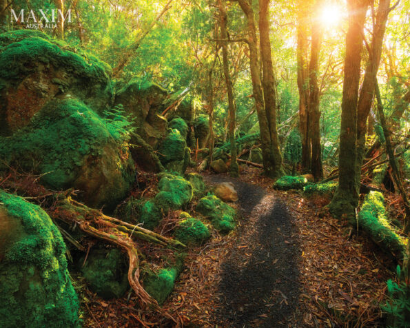
The start of the chosen walk from Waterfall Bay will take you straight to a lovely spot overlooking a gorgeous waterfall that plunges 200m into the sea. As you wander up past the long, winding, stringybark forest and slowly gain elevation you’ll hear plenty more stories from your guide, like the one about local members of the Country Women’s Association (CWA) many years ago making beer out of the sassafras plant that grows abundantly where you are walking. Rumour has it that sassafras beer contained certain amphetamine qualities that made it popular with the men.
Soon you’ll be walking in thicker rainforest and every so often through the trees you’ll get sweeping coastal views. The best view, however, is from Tatnells Hill, which stands 548m high. The panorama of the towering sea cliffs the area is famous for, surrounded by deep blue ocean, is breathtaking. As we sipped tea and took in the surrounds, we listened to Danny talk more about Martin Cash. During his time on the run Cash heard Bessie Clifford had deserted him for another and he risked a visit to Hobart Town to see her. He was captured and tried for killing one of his pursuers. Some popular sympathy had been aroused for Cash and somehow he escaped the noose, instead being given a further 10 years in prison: this time on Norfolk Island, where among other things he became a hat maker.
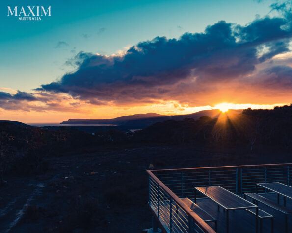
Over the next several hours of walking the trail from Tatnells Hill winds its way down towards Fortescue Bay, which has to be one of the most pristine beaches you’ll ever see. The water is crystal clear and you’ll be hard pressed to resist the temptation to take a dip. It will be brisk but oh so refreshing, and is the perfect way to end a perfect day.
After breakfast on the final day, you’ll be driven back to Fortescue Bay to take a 9-km return walk to Cape Hauy. The well-made path is part of the official Three Capes Track and you can see where all the money has gone. A lot of it is paved and the steps made out of local rock have been put together like a jigsaw. Parks Tasmania certainly had a vision of making this a world-class walk, and if its popularity is anything to go by it has succeeded.
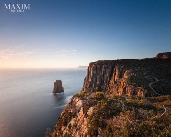
The walk starts from the boat ramp end of the bay on a path that is curvy and twisting but never out of sight. As you pop up onto a saddle you’ll get your first views of your destination. Another hour of easy walking will take you to the viewing platform just across from the exceptional rock formations of the Candlestick and Totem Pole, large columns of dolerite that rock out of the ocean. They’re just breathtaking, and what’s more amazing is that people climb them! The Hippolyte Rocks also sit severed from the mainland just east of the platform. You’ll be able to see Cape Pillar, the final section on the official Three Capes Track walk, so give yourself time to really take in the magnificence of this seascape.
You can get helicopter flights included in your tour, which gives quite a different perspective on the area. As you quickly gain altitude you can follow the trail of the official Three Capes Track from where hikers get off the boat from Port Arthur to the start of the walk. The two public huts on the trail will be visible, as will hikers who look like slow-moving ants. You’ll head out to Tasman Island, which features the highest operating lighthouse in Australia and marks the final turning point for yachts in the Sydney to Hobart race. The island is separated from Cape Pillar by the narrow Tasman Passage, which is less than 500m wide and was probably near where Martin Cash took his death-defying plunge.
So, what happened to this larger-than-life outlaw? After doing his time on Norfolk Island Cash returned to Tasmania with his new bride Mary Bennett. He worked as a gardener for a local policeman and was fully pardoned in May 1856. Cash passed away in his bed in Glenorchy, Tasmania in 1877, one of the only bushrangers to die of old age.

GREAT COASTAL WALKS AUSTRALIA by Brent McKean (Gelding Street Press $39.99rrp) is available at BIG W and all good bookstores
For the full article grab the May 2025 issue of MAXIM Australia from newsagents and convenience locations. Subscribe here.

